Do You Know Where it's Safe to Swim?
Hello from your friendly Water Quality Monitoring Program team!
We are at it again for the 2019 summer season, getting out to your favorite recreation sites to test the water and let you know where it’s safe to swim. Join us on our field day as we travel the Rogue River Basin to get reacquainted with our sample sites.
Did you know that Rogue Riverkeeper has a water quality monitoring program that collects samples from approximately 20 different locations in the Rogue River Basin to let you know if waterways are safe for recreation?
Every year, new and returning volunteers gather at the start of the summer to adopt monitoring locations at popular water based recreation sites and learn how to collect water samples for analysis. These samples are then tested for bacteria pollution, specifically E. coli, and compared to the standard bacteria levels (set by the Department of Environmental Quality) allowable in Oregon’s recreational waters. If the levels are too high, those sites violate Oregon’s water quality standards and the findings will be noted on Swim Guide as well as passed along to the Department of Environmental Quality.
Never heard of Swim Guide? Read on!

Robyn Janssen, Riverkeeper. Jesse Staten, 2019 WQ Intern. Sara Mosser, RRK Outreach Coordinator.
Because we planned to cover nearly every site we oversee in one day, as opposed to the two days we typically spend sampling, the team got an early start and headed to our first stop at Emigrant Lake.
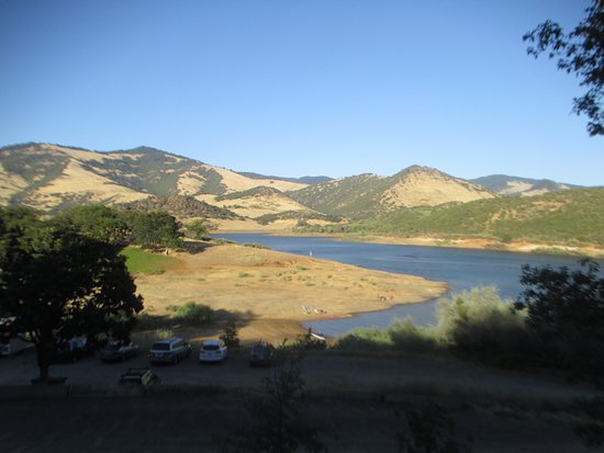
A very popular destination site for motorized and non-motorized boaters, swimmers, and anglers - Emigrant Lake typically has better water quality at the beginning of the summer than the end.
While walking out to our sample point, Robyn gave us an overview of why Rogue Riverkeeper is engaged in this work as the nonprofit’s mission is to protect and restore clean water and fish populations in the Rogue River Basin using environmental protections like the Clean Water Act.

We then headed to North Mountain Park on Bear Creek. This was our first of three sample sites along Bear Creek, and it’s often the cleanest site as it is closest to its headwaters and has yet to flow through our urban areas. Bear Creek’s headwaters begin as small mountain streams that eventually flow into Emigrant and Neil Creeks which merge to create Bear Creek. While North Mountain Park is an excellent place to visit and play, Bear Creek is often unsafe for physical contact.


Another popular playplace surrounded by natural beauty is the Lithia Park playground (see #8) adjacent to Ashland Creek. Rogue Riverkeeper partners with the City of Ashland at this site to test for bacteria, which is highly variable. In 2010, Rogue Riverkeeper launched its Water Quality Monitoring program after reports of high levels of bacteria in Ashland Creek. Check Swim Guide often as this area is often safe to play but for various reasons, E. coli levels can reach unsafe levels throughout the summer.

On to the Ashland Reservoir (see #18) - often a great place to cool off for the whole family! The reservoir, which used to supply the City of Ashland with its drinking water, is fed by clean, cool Ashland Creek. Bring your swim suit, frisbee, and lunch, but please leave your dog at home. Swimming and picnicking are allowed from dawn to dusk and there is a bathroom, drinking fountain, and grass area at the reservoir. Important to note, as this swim site is upstream from Lithia Park playground - it too can experience varying bacteria levels and can be unsafe to swim at times.

We ventured on to a new sample site on Wagner Creek in Talent. Wagner Creek is an important tributary to Bear Creek, and seeing that it is impacted by intensive logging on private land upstream as well as agriculture, it experiences variation in water quality. This is an informal area where kids and animals play in the water over the summer.
Want to get involved in restoration and stewardship on Wagner Creek? Join Friends of Wagner Creek or get involved in adopting a stormwater swale!

Our second site along Bear Creek - the most impacted waterway in the Rogue Valley - is also a new sample site for 2019.
All of the waterways that flow into Bear Creek make up the Bear Creek watershed, which stretches across 362 square miles in Jackson County, Oregon. Within the watershed, there are roughly 290 miles of streams and another 250 miles of irrigation canals that move water across the landscape. The Bear Creek watershed is largely forested (46%), but also dominated by agricultural (35%) and urban areas (18%). In fact, Bear Creek flows through Ashland, Talent, Phoenix, Medford, and Central Point before joining the Rogue River just upstream from Gold Hill.
Bear Creek has a long history of poor water quality because of its prominent location in many of the valleys towns and cities . Like many urban rivers, it’s been forgotten, pushed aside, and literally covered over in some places by the I-5 freeway. Bear Creek is impacted by polluted runoff from agricultural lands and irrigation return flow that adds bacteria, sediment, and high levels of nutrients to the water. When it rains, water that isn’t absorbed into streets, parking lots, or rooftops instead picks up pollutants and flows into Bear Creek.

Baby Bear Creek, another tributary to Bear Creek in Bear Creek Park, is a popular place for kids and pets to come into contact with the water. This site often has poor water quality and folks should use caution when recreating in this area.

Because of the water quality challenges that Bear Creek faces, this year Rogue Riverkeeper added two additional sample sites on the creek including our third site on Bear Creek at Peninger Rd. and Upton Rd. overpass in Central Point. This summer, we want to analyze how bacteria levels change over distance as Bear Creek flows from Ashland to Central Point before eventually flowing into the Rogue River.

Next we headed east toward Eagle Point to Little Butte Creek at Harnish Park. While this waterway isn’t used for recreation necessarily, it is an important tributary to the Rogue River and one of the most polluted. Little Butte Creek historically violates water quality due to impacts from agriculture and upstream development. Rogue Riverkeeper continues to look into sources of pollution in this important waterway and how we might help restore water quality in Little Butte Creek.


Leaving Eagle Point, the team continued east to Shady Cove to meet up with our new volunteer taking on sampling at Lost Creek Lake! We have several volunteers that consistently cover a site (or two!) over the summer, and this program would not be a success without them. If you would like to be a community water quality volunteer, or have an idea for additional sample sites in the future - please contact us!

We finally arrived at the mainstem of the Rogue at the Family Beach in Gold Hill. This large sandy beach on the Rogue is located near downtown Gold Hill and is a favorite swimming spot for families during the summer. A number of picnic tables and grills are available a short walk from the road and from the river. Keep in mind that this location can get very busy!
We continued north to the City of Rogue River to access Evans Creek at Palmerton Park. A tributary to the Rogue, users walk through a beautiful arboretum filled with a wide variety of trees to make their way down to the water. While Evans Creek isn’t a heavily recreated site, it does offer a cool respite for folks visiting the park during the summer months. Water levels here can get quite low due to irrigation needs for upstream farms and ranches and water quality can therefore be impacted. When water levels are low, any small amount of pollution introduced will produce E. coli levels that exceed safe water contact standards.

Onward! North to Grants Pass! We veered back to the mainstem of the Rogue to check out our sample site at Baker Park. This beautiful spot, conveniently located in the center of town is a great place to get out and enjoy a day on the Rogue River.


For some of our most remote sites, like the Rogue River at the Grave Creek Boat Ramp, and the mouth of Grave Creek under the Grave Creek Bridge - we again rely on our dedicated volunteers. The Grave Creek boat ramp, a popular location to access the the beginning of the Wild and Scenic section of the Rogue, is managed by the Bureau of Land Management near rivermile 68. This location is heavily used as a launch site by boaters heading down the Rogue’s Wild & Scenic multi-day stretch.


Rogue Riverkeeper oversees two sample sites on the Illinois River just outside of Selma. Six Mile Day Use area on the Illinois is a popular swim spot with clear water and accessible swimming holes. Iron Ring picnic site is just downstream from Six Mile Day Use area and is our second sample site on the Illinois.

Applegate Lake at Hart-Tish Park is a beautiful, accessible, recreation area that offers day use areas for swimmers and also a cement boat ramp. Camping is nearby, kayak rentals are available, and trails around the lake provide hikers and mountain bikers additional recreation opportunities.

The Applegate River, flowing from Applegate Lake, has many swim spots as it flows through the Applegate Valley! Rogue Riverkeeper samples at Cantrell Buckley Park, a sweet spot for family activities and outdoor adventures.

On a typical sampling day, after our Water Quality Intern rounds up all of the samples - then what happens? The samples return to the lab, on ice and within 6 hours. They are quickly processed and incubated for 24 hours. We then read the samples to determine the levels of E. Coli present in the water and upload the findings to The Swim Guide.
The Swim Guide is a valuable resource! Easily accessible and fun to use, Swim Guide is a website and smartphone app that allows you to find your closest beaches and recreation sites to find out which ones are safe for swimming! You can easily check to see if some of your favorite local swimming and boating spots meet the recreational water quality standard on our Swim Guide page. Remember, as lake and river levels drop, the water quality generally gets worse as there is less water to dilute bacteria, and water temperatures increase leading to conditions in which bacteria thrive. Be sure to check the Swim Guide often to see if your preferred beach is still safe!
Want more? Navigate to the main Swim Guide site to learn more about over 7,000 beaches in the U.S., Canada, Mexico, New Zealand, the Bahamas, and Australia.
We hope to see you out on the water this summer!

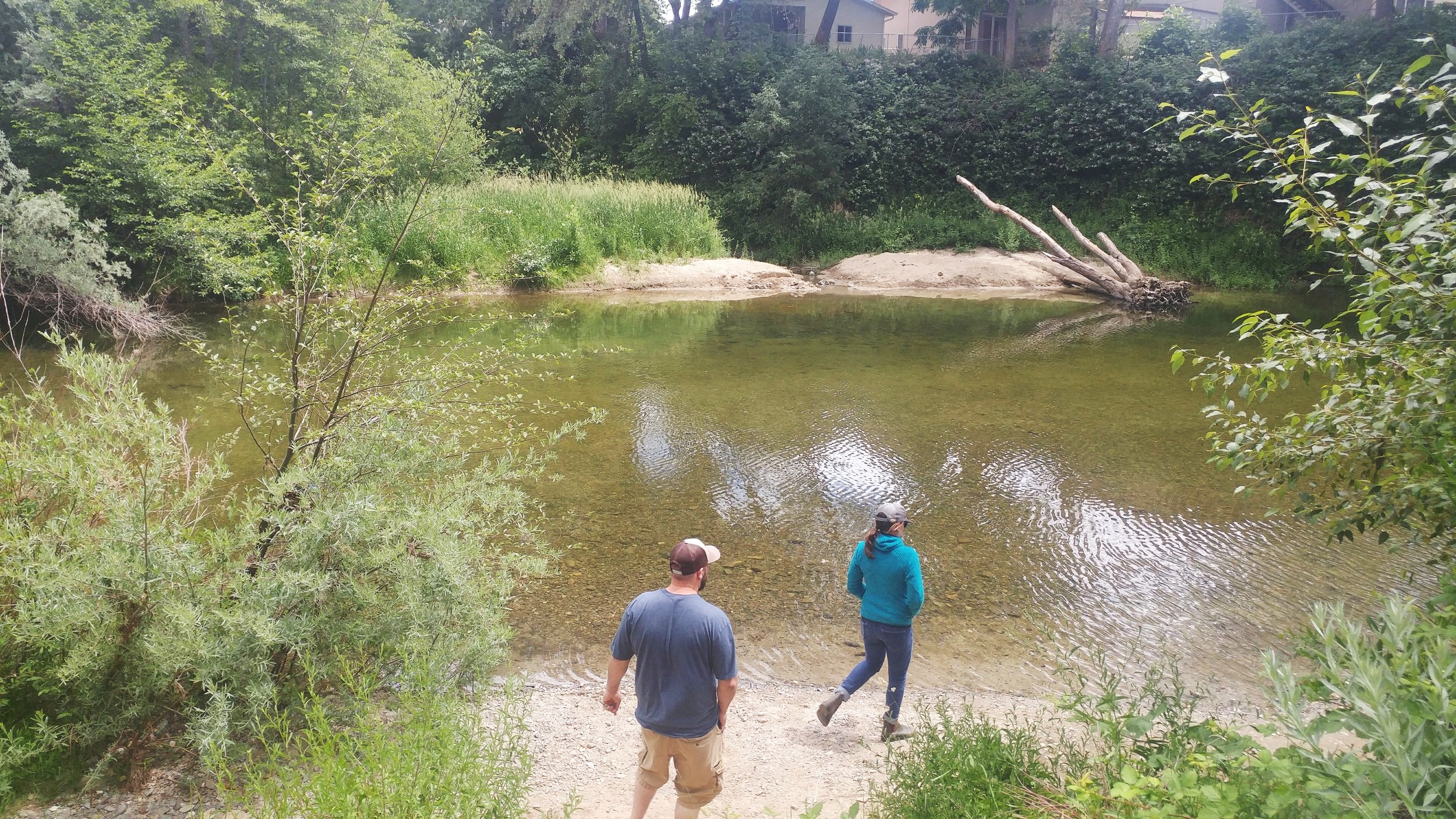
As our field day came to an end, traversing the Rogue River Basin from Ashland to Shady Cove area, to Grants Pass, to the Applegate Valley - we decided to take a short detour to investigate a small tributary of Larson Creek which is a tributary to Bear Creek in east Medford.
A couple years ago, Robyn had come across this creek by chance and noticed salmon swimming in its waters!! While summer is not the time of year to see spawning salmon are in our creeks, it was encouraging to know that our local salmon are using our waterways and overcoming obstacles associated with urban uses.
